
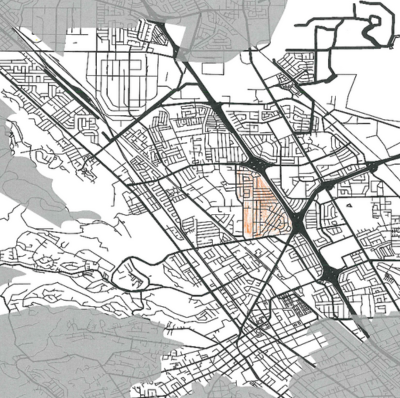
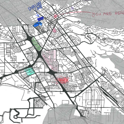
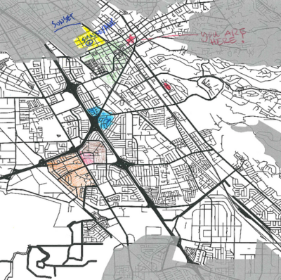
Publicly Submitted District Maps
Click each image below to view the full-sized map.
Each map includes a link to download shape files of the submission. A Shape file (shp) consists of 6 files that cannot be opened separately by other programs. If this shape file is imported into a mapping program, it will render the map that is provided in pdf format. Mapping programs that can open shp files include QGIS, ESRI/Arc programs, Maptitude and Google Earth Pro.

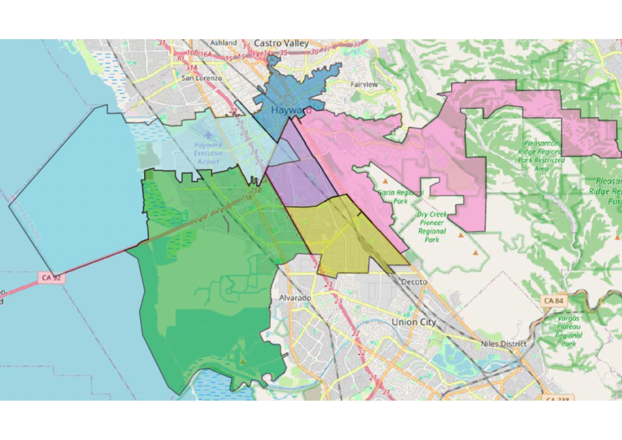


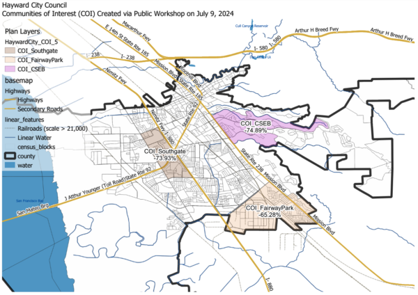
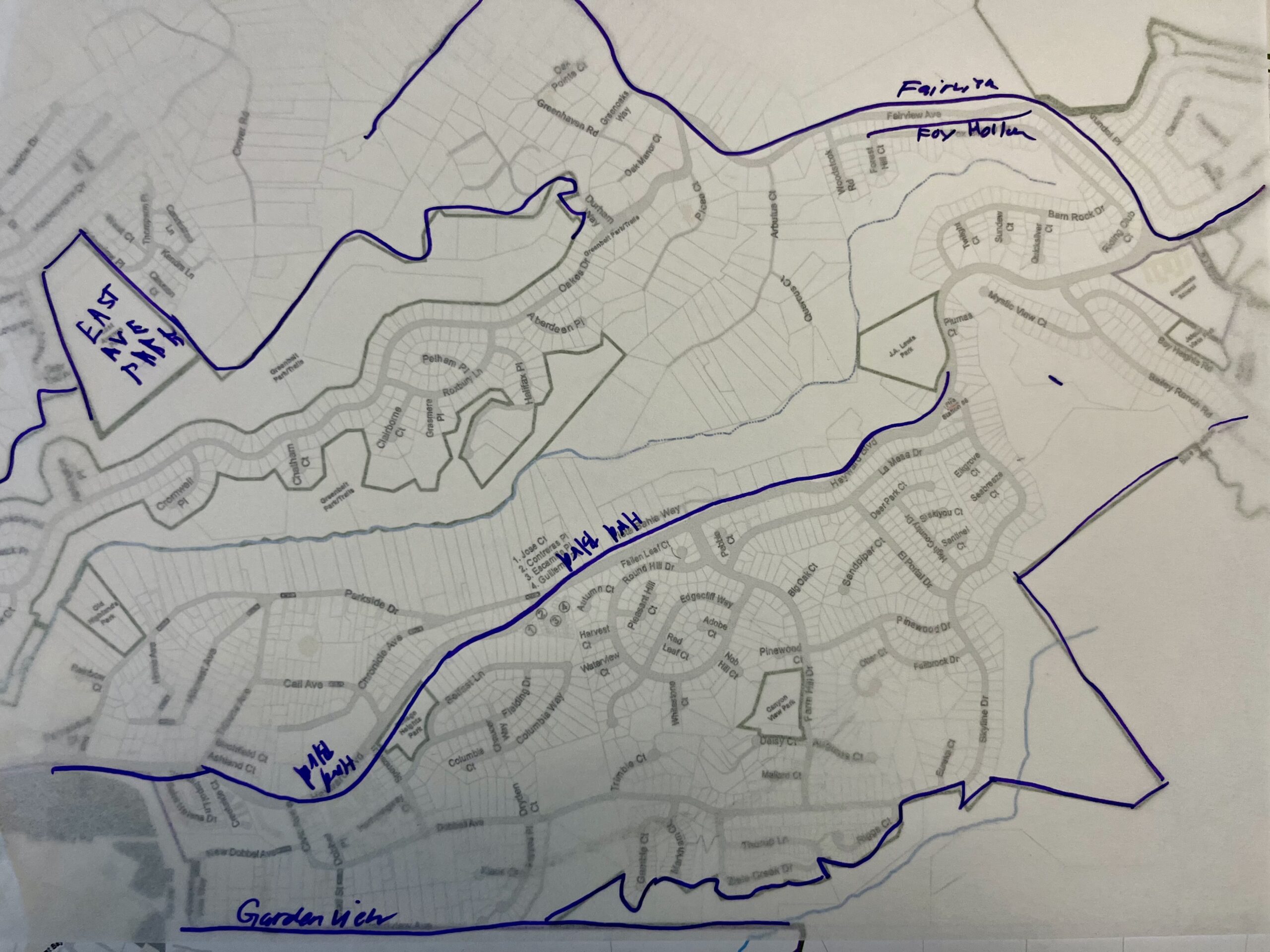
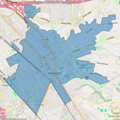
Community of Interest (COI) Map:
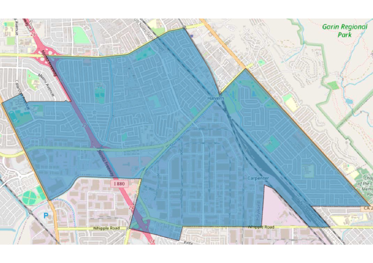
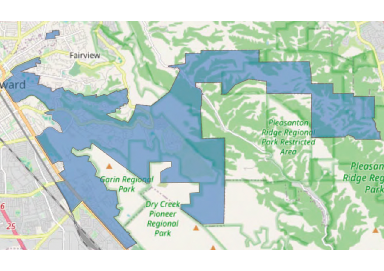
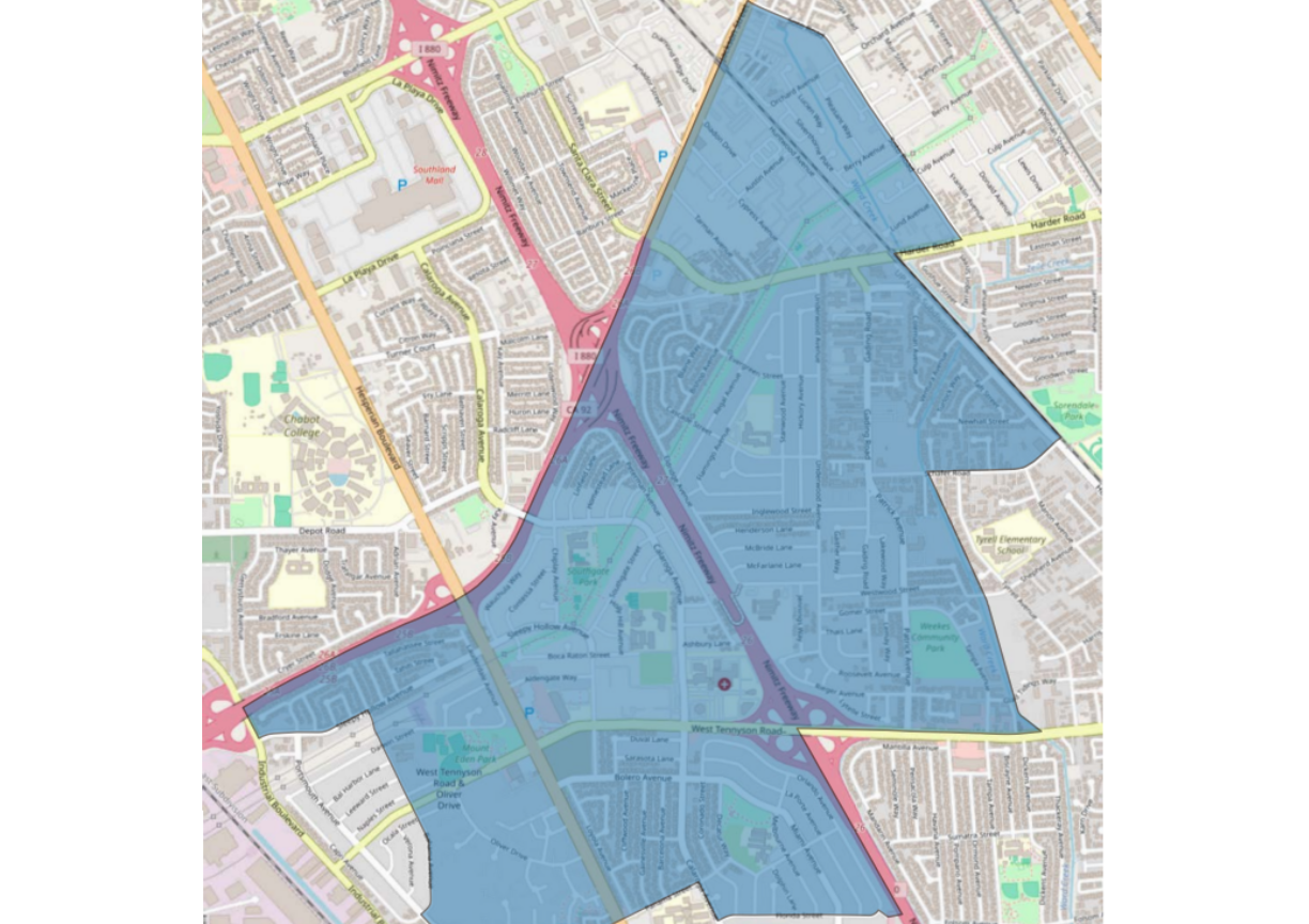
- Single district map: Cal State East Bay
- Single district map: Fairway Park
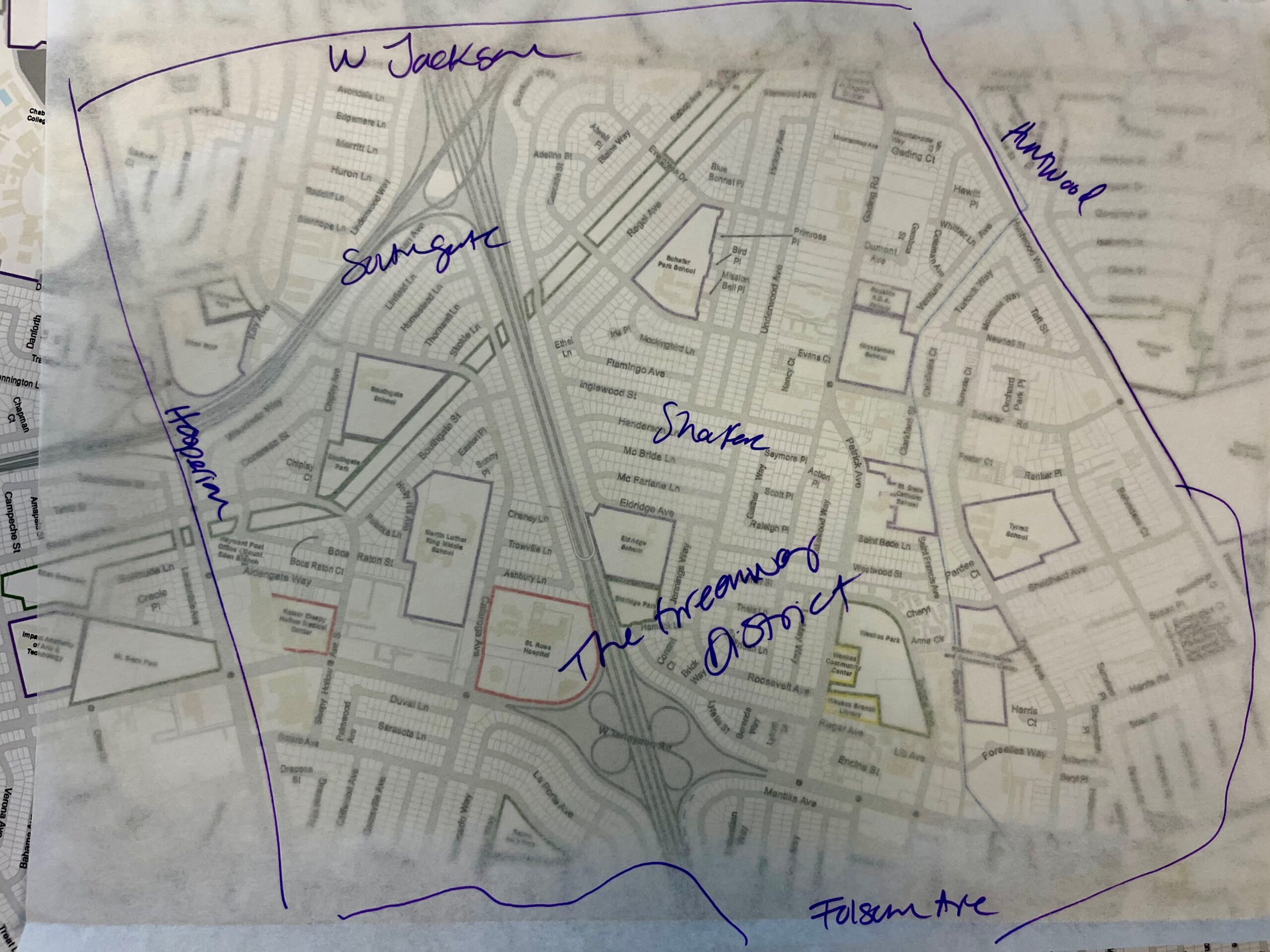
- Single district map: Southgate
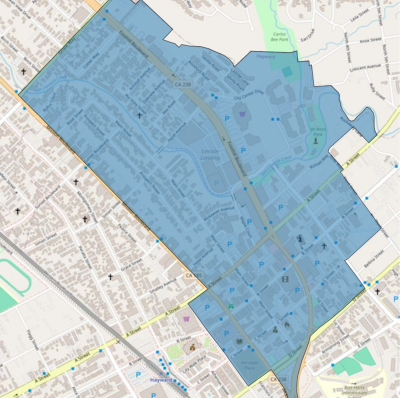
- All three communities (Cal State East Bay, Fairway Park, Southgate)
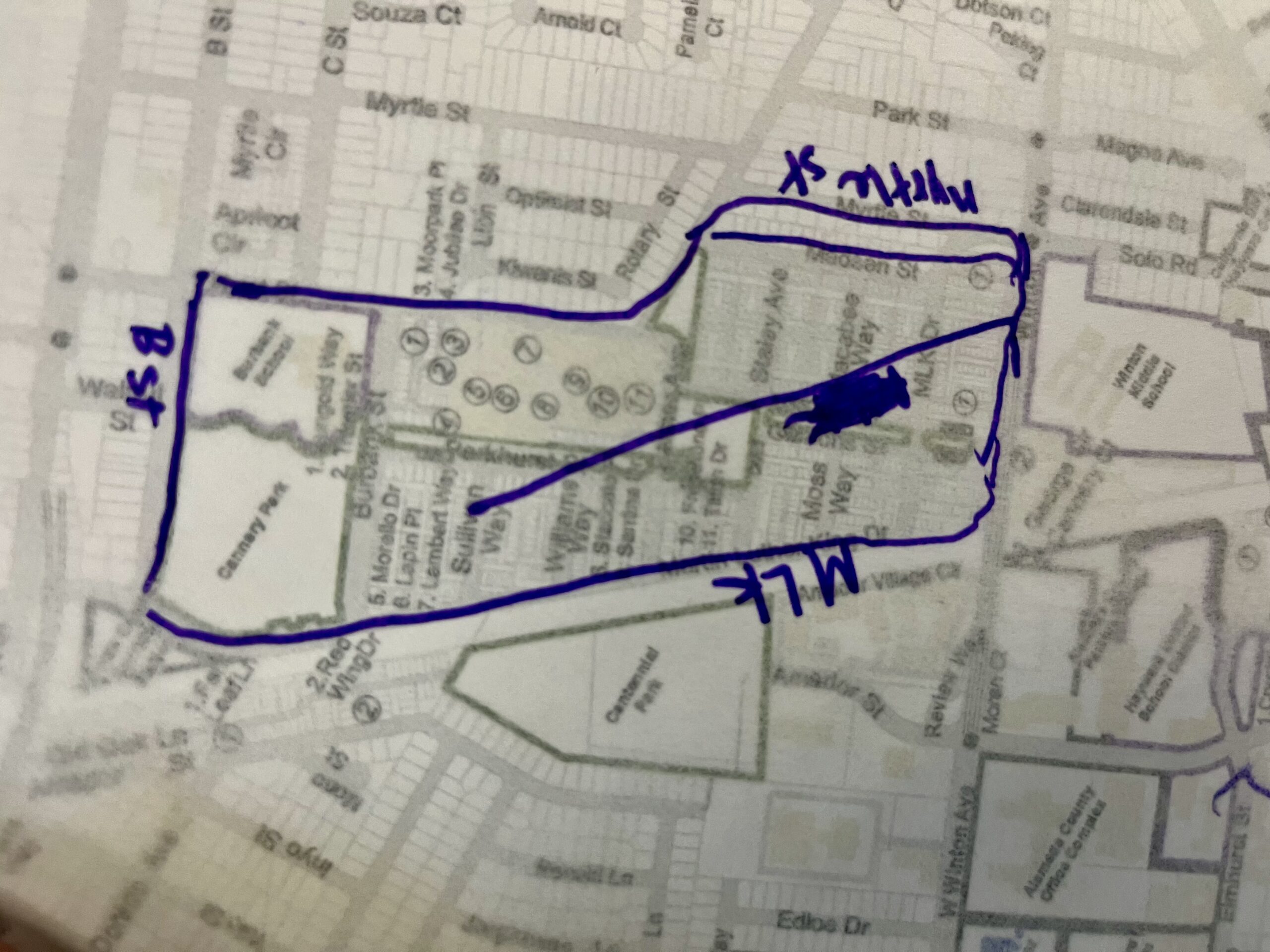
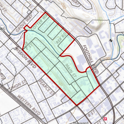
Community of Interest (COI) Map:


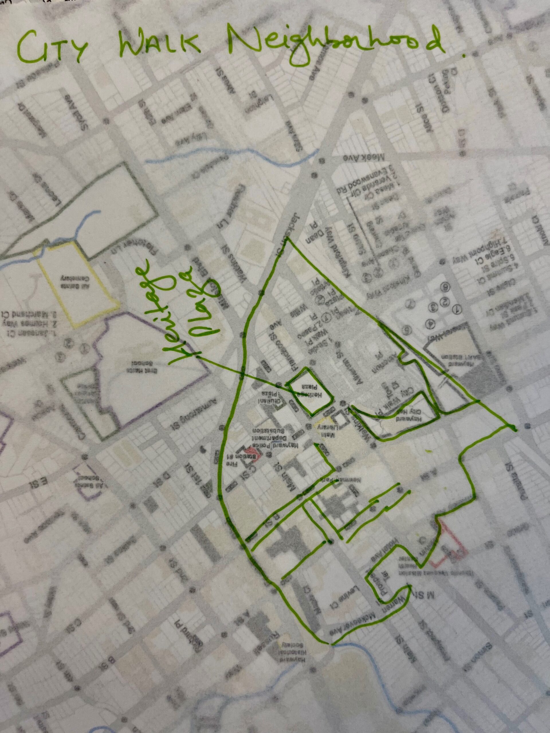
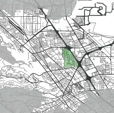
Started building districts with the whole Jackson Triangle neighborhood.
PDF map
Submission PDF
Map statistics
Downloadable shape files of the submitted map
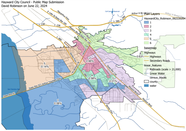
This map has 3 equal, compact districts that would use two-seat ranked choice voting, electing candidates receiving a separate 1/3 of a district’s vote (so at least 2/3 of voters accountably support the winners). If each census group votes as a block, Asian voters would elect at least 2 candidates, and Latino voters another 2. This contrasts with my 6-district map that could elect only 1 of each from non-compact districts. This plan would require modifying the California Voting Rights Act settlement by mutual agreement.
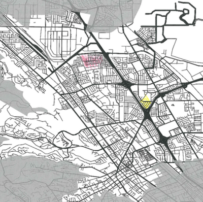
PDF map
Submission PDF
Map statistics
Map description
Downloadable shape files of the submitted map
In March, plaintiff’s attorney Scott Rafferty wrote: “It is possible to create at least one district that is majority Asian, which likely triggers liability under the federal Voting Rights Act.” He did not present a map. Here is one, also including a majority Latino district. There is a clear tradeoff between these voting rights goals versus compactness and other Community of Interest considerations.
PDF map
Submission PDF
Map statistics
Map description
Downloadable shape files of the submitted map
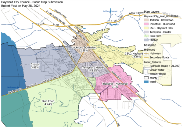
I have constructed the districts to meet the requirements of population balance, contiguity, and reasonably compactedness. Communities of interest—as illustrated in the provided spreadsheet and my own understanding of the city I live in—help shaped the neighborhoods that I wanted to keep intact. But, with our population being diverse across the city, there are no large communities of interest that will nicely fit into one district. For example, the AAPI community has a large population percentage in the northwest and southeast regions. It would have been impossible to construct one district and still maintain the requirements, such as reasonable compactedness or contiguity. My goal was to ensure that I maintained the neighborhoods within the communities of interest. Once identified, I used geographic features, such as roads, rail, water, etc, to provide a natural social boundaries.
PDF map
Submission PDF
Map statistics
Downloadable shape files of the submitted map

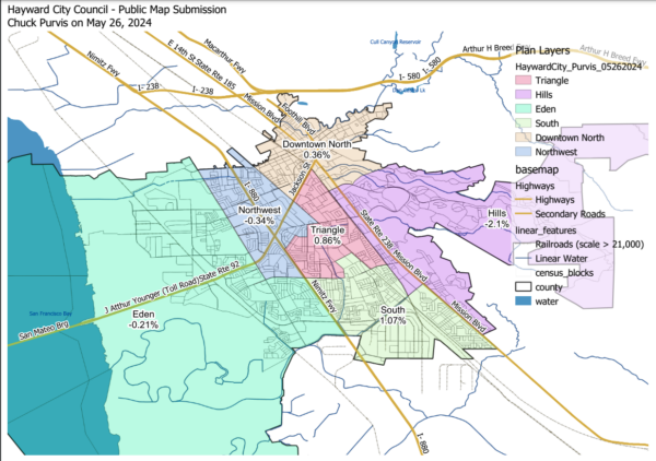
Compact, contiguous, nearly equal districts prepared without looking at the census category numbers. I will submit an identical spreadsheet version by email.
PDF map
Submission PDF
Map statistics
Downloadable shape files of the submitted map
These districts were constructed in a clockwise fashion, starting with Downtown / North (North Hayward, Downtown, Upper B Street, Burbank); to the Hayward Hills (Mission-Foothill, Hayward Highlands, Mission-Garin); to South Hayward (Fairway Park, Tennyson-Alquire); to Eden (Eden Shores, Glen Eden, Mt. Eden); to Northwest Hayward (Southgate, Longwood-Winton-Grove, Santa Clara); and finishing with the Triangle (Jackson Triangle, Whitman-Mocine. Harder-Tennyson). All districts are within 5 percent of the ideal size, and four of the six districts are within 1 percent of ideal district size. This plan would have two Asian plurality districts (Hills, Eden); and four Latino plurality districts (Downtown, South, Triangle, Northwest).
PDF map
Submission PDF
Map statistics
Downloadable shape files of the submitted map


Attached is a zip file containing the Hayward block level GIS files (shx, shp, dbf, qix, prj.) These are my first two council boundary submissions. I created these in QGIS in early May, in anticipation of the May 14th meeting with City Council.
I’ve checked out the redistricting map website. It looks a lot easier / cleaner than using QGIS!!! I’ve registered on there, as ….
I’ve also attached maps of my first two alternatives. Maybe let’s name them “Atherton #1” and “Atherton #2” after my home street?
Four variables are relevant in my GIS files:
“hayward” – – which refers to the 18 neighborhoods (16 created by the City Council, and adding in Eden Landing and Downtown Hayward as neighborhoods.)
council1 = Alternative Atherton #1. This is a simple aggregation of the 18 Hayward neighborhoods, no adjustment.
council2 = Alternative Atherton #2. This is my attempt at equalizing the six districts.
GEOID = the detailed Census geographic ID, for linking to whatever master file you have. (state+county+tract+block).
The PL 94-171 data in my files are the original PL 94-171, not the adjusted populations. Thanks for providing the reference to these adjusted PL 94-171 files in your Excel workbook!!
Somewhere in my process I lost two blocks: there should be 1,478 and I have only 1,476. But my population totals match the Census PL 94171 values, so my “missing blocks” are apparently zero population (or water blocks?)
Could you upload these two alternatives as my submission? I’d like to add some written discussions about the strengths and weaknesses of each.
I think adding the 18 Hayward neighborhoods as a display option in the online mapping tool might be beneficial.
Thanks for your presentation on May 14th, and I’m looking forward to more work on this.
Alternative 1
Alternative 2
Downloadable shape files of the submitted map
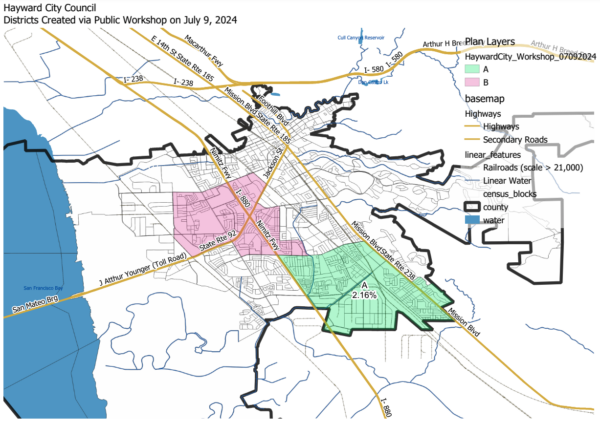
Community of Interest (COI) Maps
Click each image below to view the full-sized map.
Some COI maps include a link to download shape files of the submission. A Shape file (shp) consists of 6 files that cannot be opened separately by other programs. If this shape file is imported into a mapping program, it will render the map that is provided in pdf format. Mapping programs that can open shp files include QGIS, ESRI/Arc programs, Maptitude and Google Earth Pro.
This map was created by a member of the public.
This map was created by a member of the public.
This map was created by a member of the public.
This map was created by a member of the public.

This map was created by a member of the public.
This map was created by a member of the public.
This map was created by a member of the public.
This map was created by a member of the public.
This map was created by a member of the public.

This map was created by a member of the public.
This map was created by a member of the public.

This map was created by a member of the public.
This map was created by a member of the public.
This map was created by members of the public who reside in the Communities of Interest indicated. It was submitted following the Downtown Street Fair on July 18, 2024.
This map was created by members of the public who reside in the Communities of Interest indicated. It was submitted following the Downtown Street Fair on July 18, 2024.
This map was created by members of the public who reside in the Communities of Interest indicated. It was submitted following the Downtown Street Fair on July 18, 2024.
This map was created by members of the public who reside in the Communities of Interest indicated. It was submitted following the Downtown Street Fair on July 18, 2024.
This map was created by members of the public who reside in the Communities of Interest indicated. It was submitted following the Downtown Street Fair on July 18, 2024.
Hello. Please see my map of my neighborhood, per your request.
I have feedback about your map-drawing tool: it was adequate enough, but there was no clear way on how to submit a map to you. If you really want people to submit these things, you have to make it clear how to do so. I had to ask a reporter, and it was frustrating.
Hi Council, sharing what I believe is the difference between the downtown and highlands neighborhood – within the five percent deviation allowed according to the first public hearing. I have lived in both “districts”. The downtown neighborhoods are all within walking distance of the shops and the BART station downtown. The Mission-Highlands district is primarily suburban and revolves around Garin Park, the CSU, and the green belt trail. It’s a hillside community.
Describe your community
Give your community a name*
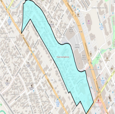
Hazel
Tell us about your community. What are your shared interests? What brings you together? What is
important to your community?*
Hazel & Main St. are a cornerstone of our neighborhood. Many of us have lived here for decades. Neighbors
know eachother and work together on the hazel garden project. We typically are grouped with ‘Cherryland’
but we do not feel a part of cherryland at all. We are seperated by Mission St. and the large hills on Simon
and Sunset so we do not generally associate. We call our neighborhood Hazel.
Are there nearby areas you want to be in a district with? Nearby areas you don’t want to be in a district
with? Why or why not?
We do not want to be grouped in with Cherryland or Ashland. We need our own district. We prefer to be
grouped with neighborhood along San Lorenzo creek. Do NOT group us with the new mega condos Lincoln
Landing which should have never been built.
Is there anything else you can tell us about your community?
We’d love more walking paths along the san lorenzo creek
Christopher Cara on October 1, 2024 at 2:28 p.m.
Dear Councilmembers and Mayor,
My name is Christopher Cara and I am a homeowner in District A/4 of Hayward. I’ve grown up here having attended St. Bede school and Moreau High School. I am the prevention director at Filipino Advocates for Justice. We are a 50 year old 510(c)3 organization that has been serving the Filipino / AAPI community in Alameda County to build a strong and empowered Filipino community by organizing constituents, developing leaders, providing services, and advocating for policies that promote social and economic justice and equity. We serve and organize many Hayward youth, young adults and elders out of our south county office.
We would like to advocate for District A/4 to be in the Presidential 2028 election, both as a resident of that district and a member of the AAPI community. Presidential elections tend to have more voter participation than midterm elections. With District A/4 being a high AAPI population, approximately 45% AAPI, it’s imperative that it has the highest voter turnout possible.
I love this city and am committed to working with you all to improve the lives of working class residents of Hayward. I appreciate you for your taking your time and providing consideration.
Geena Ballesteros on October 1, 2024 at 2:12 p.m.
Dear Councilmembers and Mayor,
My name is Geena Ballesteros, and I am a lifelong Hayward resident. My parents are home owners in Hayward and both myself and my siblings rent in the city. We’ve all grown up here and are raising the next generation in HUSD schools as well as running a small business in Hayward.
I am the Transition Age Youth Organizer with Filipino Advocates for Justice. Thank you for your time and diligence in this districting process, we appreciate your efforts. FAJ is a 50 year old 510(c)3 organization that has been serving the Filipino / AAPI community in Alameda County to build a strong and empowered Filipino community by organizing constituents in the city of Hayward, developing leaders, providing services, and advocating for policies that promote social and economic justice and equity. I’ve benefitted from this organization’s work personally since I was a 14 year old student at Mt. Eden.
We would like to advocate for District A/4 to be in the Presidential 2028 election, both as a resident of that district and a member of the AAPI community. As an organization that primarily focuses on nonpartisan Get Out the Vote in cities like Hayward, Presidential elections tend to have more voter participation than midterm elections. With District A/4 being a high AAPI population, approximately 45% AAPI, it’s imperative that it has the highest voter turnout possible to have a better count of representation.
Thank you again for your time and consideration.
Daisy Maxion on October 1, 2024 at 2:11 p.m.
Dear Councilmembers and Mayor,
My name is Daisy Maxion, and I am a resident of District A/4 of Hayward. I am the Organizing Director with FAJ Action Fund. Thank you so much for your time and diligence in the districting process, the community truly appreciates your efforts especially with the quick turnaround.
FAJ Action Fund is the 501(c)4 sibling organization of Filipino Advocates for Justice advocating for Filipino interests on all aspects of life that affect the general well-being of Filipinos in California, especially in the City of Hayward by educating, empowering, and mobilizing our Filipino progressive voter base.
We would like to advocate for District A/4 to be in the Presidential 2028 election, both as a resident of that district and a member of the AAPI community. Presidential elections tend to have more voter participation than midterm elections. With District A/4 being a high AAPI population, approximately 45% AAPI, it’s imperative that it has the highest voter turnout possible.
Thank you again for your time and consideration.
Louise Leavitt on September 28, 2024 at 3:51 p.m.
Most residences of Hayward, including myself, have NOT received any information about districting, nor can we read/understand the maps shown on this website. Our HMOA (9 mobilehome parks in Hayward) forwarded information about the upcoming meeting on Oct. 1st at City Hall, but we are in our 80’s and unable to attend.
WHY HAVEN’T WE RECEIVED THIS IMPORTANT INFORMATION SOMETIME BETWEEN APRIL/MAY 2024 AND NOW, SEPTEMBER 28, 2024 FROM THE CITY COUNCIL VIA EITHER REGULAR POSTAL MAIL, EMAIL, OR PHONE CALL??? i AM VERY DISAPPOINTED OVER THIS, BUT GLAD OUR HMOA FOUND OUT ABOUT THIS ON SEPT. 26. DON’T YOU CONSIDER ALL HAYWARD RESIDENTS HAVE A RIGHT TO BE INFORMED SO WE CAN VOITE ON THIS??? DISAPPOINTED RESIDENT, LOUISE LEAVITT
Louella Lopez on September 11, 2024 at 5:52 a.m.
Hello,
Of all the draft plan maps, I prefer draft plan 2. (HaywardCity_Draft2)
I believe the bounds of District E should be Mission Boulevard, Tennyson Road, and Nimitz Freeway.
There is a community called Spanish Ranch which I especially believe should be part of District E. Spanish Ranch is made of elderly residents as well as families with children. The places of interest for them are Ruus Elementary, Ruus Park, and Folsom Avenue. Children of Spanish Ranch attend school at Ruus Elementary. Residents of Spanish Ranch often go in the afternoon hours for their walks at Ruus Park as well as along Folsom Avenue. Also the entrance of Spanish Ranch is at Folsom Avenue.
I don’t believe they spend a lot of time crossing Tennyson Road.
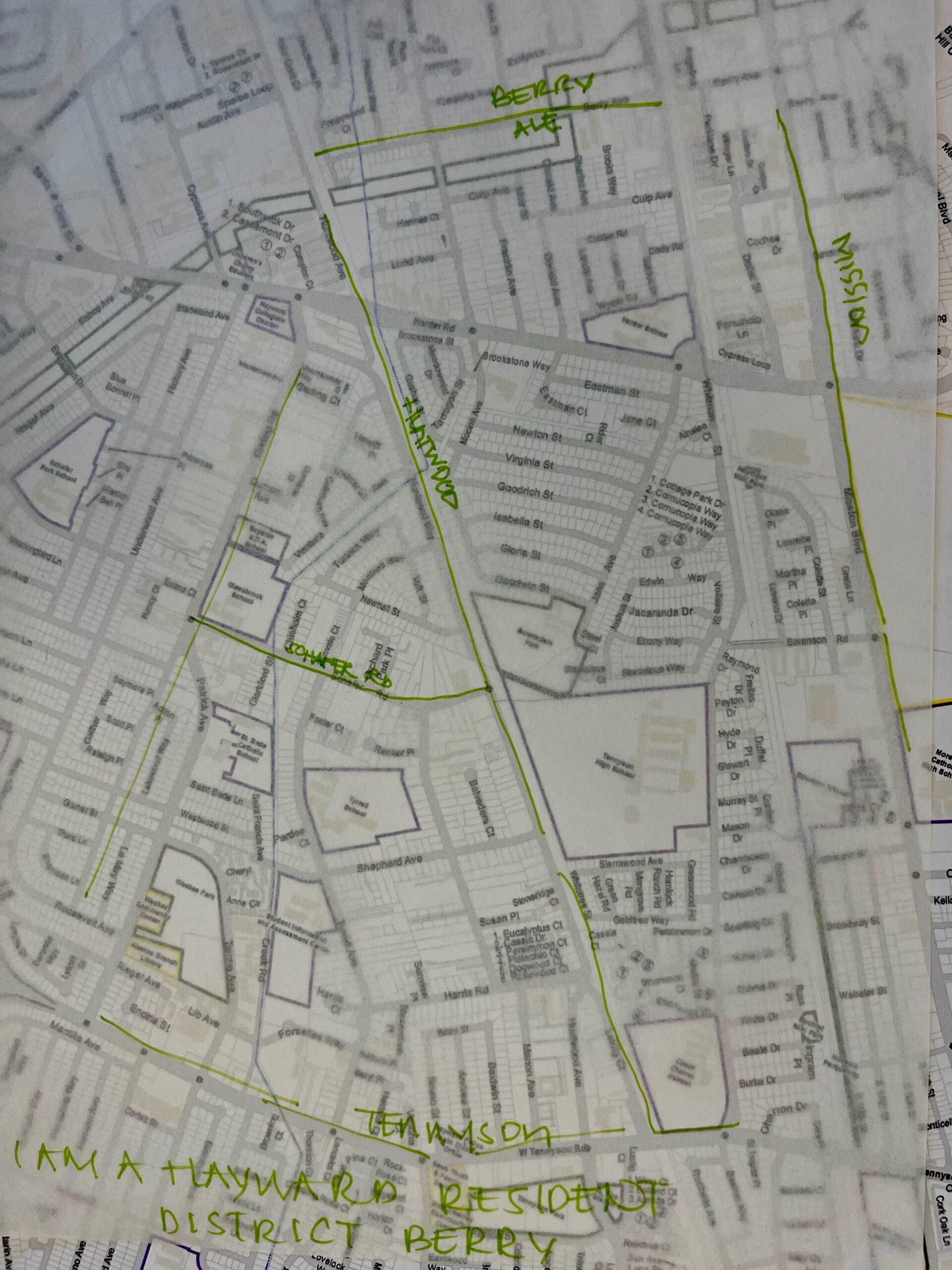
Pauline Wong on September 9, 2024 at 9:02 p.m.
Hello There,
It appears that Hayward citizens not were given much time to learn and to carefully study the proposed maps before the final map was proposed. Therefore, I would like the City Council to please revisit Draft Plan 2 map proposed on 8/27/24.
I live in the Tennyson/Alquire and I feel that Tennyson/Alquire area is adequately captured in green as portrayed in the Draft 2 map. Geographically, I feel that it would make sense to use this map as the final version since I also shop, exercise in a nearby gym, have friends and their kids attend the schools in the neighborhood.
According to the data, Asians represents 36.8% and because I’m Asian, I feel that the census number in the map would be a more accurate representation of the population of the area as captured in green labeled as District E.
Please reconsider Draft Plan 2 which I feel better represents me and the area I reside in.
Thanks,
Ron Dingel on August 30, 2024 at 9:46 a.m.
I don’t like this idea about district voting, I want to vote for all people who want to be in city politics.
Sara Lamnin on August 28, 2024 at 2:17 p.m.
Hello!
Sending along this note in support of Draft Map 3 as it appears to keep a large number of communities of interest intact. It also respects community boundaries.
Thank you very much for your dedication to an inclusive process.
Rebecca Parr on August 28, 2024 at 11:07 a.m.
Please add more street names to the proposed district maps. As submitted, they are impossible to interpret and virtually useless. Thank you
Yenifer Origel on August 20, 2024 at 10:24 a.m.
The map tools are extremely difficult to use; not user friendly!
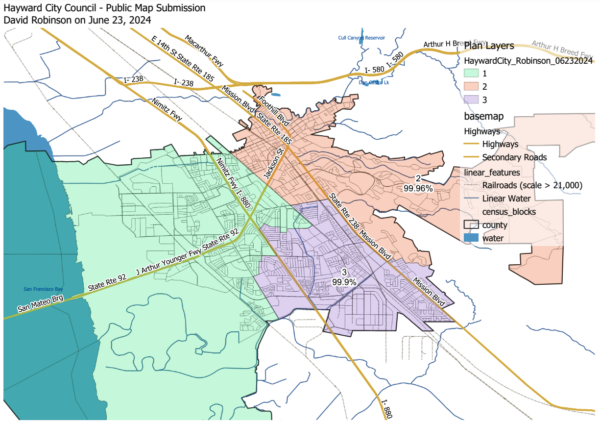
David Robinson on June 30, 2024 at 8:56 p.m.
Here are some slides describing my June 22 and 23 map submissions that are more human-readable than the output of the online districting tool. Please post these on their corresponding pages at:
3-district map: https://maphayward.org/june-23-dave-robinson/
6-district map: https://maphayward.org/june-22-dave-robinson/
or on a new page.
Undiluting Hayward’s protected groups by thinking outside the lines
Hayward City Council map with majority Asian and Latino districts
Gina Jorquez Pacaldo on June 27, 2024 at 1:08 p.m.
Hello,
Sending a few comments & questions that come to mind. Both my husband Jesse Allen, & I are homeowners at [ADDRESS REDACTED] – as of 10/1992.
We basically love our home & as we’re aging gracefully, we are becoming more concerned about safety – based on recent too close to home invasions/robberies;
the dumping of debris, garbage in the alleyway parallel to Mission – between Simon & Sunst; and the unhoused folks in the car dealership on Simon & Mission.
Re: your mandate to work on mapping districts to reflect Asian American representation – I’m wondering about the following;
1. Is there a particular Hayward District that is predominately Asian?
City Response: The districts have not yet been drawn. Districts must comply with many constitutional and statutory criteria. First, districts must be roughly equal in population. The districts must also comply with federal law, specifically the Federal Voting Rights Act, which aims to ensure that protected groups, if certain criteria are met, have the ability to elect a candidate of their choice. The Council will be discussing specific maps in upcoming hearings, including the demographic features of districts. The Council has not discussed draft maps yet.
2. If so, is that based on the recent census?
City Response: The data used to draw districts is the 2020 federal census data with adjustments as required under California law.
3. If not, what data determines the racial ethnicity of a District?
City Response: See above.
4. Is home ownership a consideration to determine who’s who in a District.
City Response: No. The data used to draw districts includes all residents without regard to home ownership.
5. Does one have to be a homeowner to represent a District?
City Response: No. To represent a district, a candidate must reside within that district but does not need to own a home in the district.
6. How many Districts are there now?
City Response: The Hayward City Council currently utilizes an at-large election system for its City Council, which means that voters from the entire City elect all six Council members and the Mayor. The council members are eligible to hold office no matter where in the City they reside. A by-district election system, in contrast, is one in which the entire City of Hayward is delineated into separate electoral districts, each with one City Council member who resides in the district and is chosen by the voters residing in that respective district. Districting is the process of transitioning from an at-large to a by-district election system.
7. Will this remapping effort include creating or reducing Districts now?
City Response: The City is in the process of transition from an at-large to a by-district election system. This is the first time the City will draw districts and it will hold by-district elections in 2026.
8. I’ve observed that many homes in Alameda County have been purchased by Asian individuals & investors.
9. Wondering who exactly filed the law suit against the City of Hayward?
City Response: The lawsuit was filed by attorney Scott Rafferty.
10. Who do they represent?
City Response: The plaintiff in the lawsuit was an individual named Jack Wu.
11. Wondering what District is the “Prospect Hill” a part of?
City Response: The Council has not yet voted to approve any district map, so we do not yet know which district/s will contain Prospect Hill.
We appreciate your input and would welcome your participation in upcoming redistricting meetings!
The context of my questions arise as I imagine writing “something” – perhaps, based along the mission of storycorps.org – that would feature willing neighbors that would like to participate.
Yes, since we’ve lived here- it’s evident that more Asians – I believe, primarily Chinese – are our neighbors in a 3 block area of Prospect St. – from Warren to Sunset. And, we all add to the diversity of our Community.
In the block we live on – including those across the street-reflect changing demographics of Hayward. Proud to say our diversity is Beautiful! Including Indigenous American Indian, Mexican, African-American, Gay Pakistanís, Devout Yemen Muslims, Anglo, Iranian, Filipino, White, Asian, Punjabi & others! And, yes, there’s Gay Pride History on this lil’ hill- from the days of original homeowners that were stellar Artists & individuals.
With a wide eyed perspective of ongoing changes in our neighborhood-
I’m wondering what are the benefits? And, costs to do this remapping endeavor?
Please share my questions & concerns. I don’t expect you to answer all my questions – yet, would be great to initiate conversations.
Thank you for your attention & time.
Chuck Purvis on May 31, 2024 at 2:33 p.m.
Mayor and City Council, and Districting Consultant:
Attached are several maps showing 2020 Census block-level population by race/ethnicity.
Separate maps for shown for:
1. Hispanic/Latino
2. White (non-hispanic)
3. Black (non-hispanic)
4. Asian (non-hispanic) and
5. Native Hawaiian / Pacific Islander (non-hispanic)..
Two additional maps show the leading (plurality, most prevalent) race/ethnicity group by block level, and the second leading race/ethnicity group. Earlier versions of these two maps were shown at the May 28th Council Meeting.
All of these maps are “Dorling Cartograms.” They’re like graduated symbol/bubble maps, but the Dorling algorithms “push”(or repel) each of the symbols/bubbles away from each other so that they don’t overlap.
I hope this is of use to the City! I will be out-of-country and will return June 12th. If I can be of further assistance, please let me know.
Hispanic/Latino
White (non-hispanic)
Black (non-hispanic)
Asian (non-hispanic)
Native Hawaiian/Pacific Islander (non-hispanic)
Largest racial group by block
Second leading racial group by block
Dwight Turner on May 28, 2024 at 1:56 p.m.
Districting Process
Community of Interest
My Community
Describe your community
Community Name:
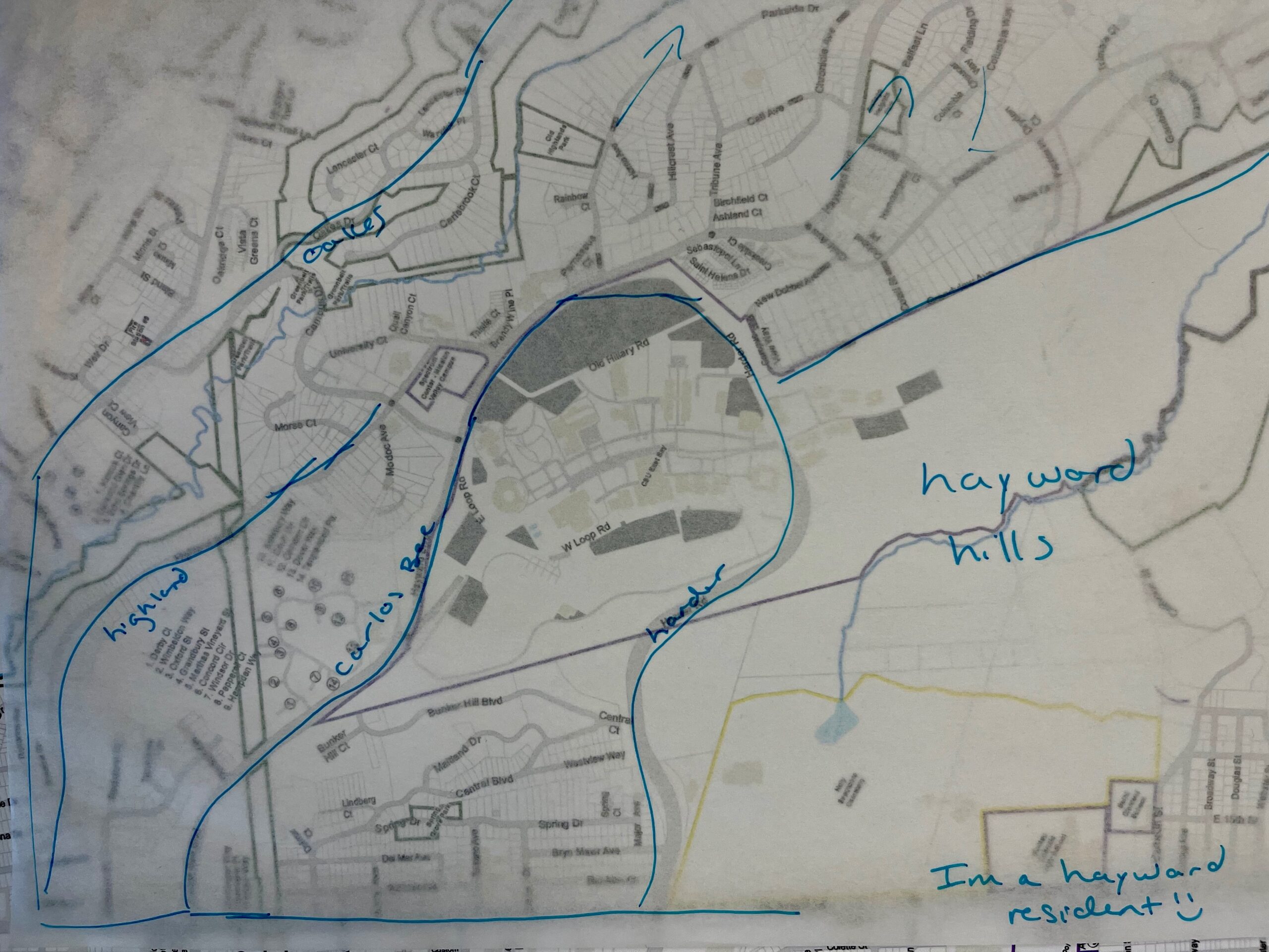
Hayward Hills
Description
Unique Shared Concerns:
Topographically this is some of the highest elevations in the city. So the weather is different here than the flat lands. This area occasionally experiences snow, hail, thick fog, high winds and freezing rain. Therefore road and driveway grades should consider these possible conditions.
Road egress is largely dependent on Hayward Boulevard and Fairview Road. Therefore the area is very sensitive to increase traffic during normal conditions and residents have expresses serious concern in emergency situations that could close access to either/both road or the road becomes clogged with excess traffic.
Wildland interface areas share a boundary with much of this area. Therefore wildfires, erosion and flooding are all situations of high concern. Some residents have reported insurance coverage issues due to these conditions.
Common Shared Concerns:
Maintaining Home Values is a concern since many of the homes were built less than 30 years ago. Therefore anything that might disrupt the appreciation trend would be viewed as adverse.
Security is a big concern. Since these communities are remote to rest of the city it appears that they get less patrols and poor response.
Maintain Diversity. It appears these areas are very diverse and peaceful and we want to continue to maintain this.
Boundary of Community of Interest
At a minimum it should include:
Prominence
Stone Brae
Bailey Ranch
Possible other communities
Other communities along the Hayward Boulevard needed to meet the size requirement for the district.
Dwight Turner on May 28, 2024 at 1:54 p.m.
The password maybe the id also are incorrect for tonight’s meeting.
Chuck Purvis on May 28, 2024 at 11:44 a.m.
Mayor Salinas and City Council:
Attached is a summary of data on Native Hawaiian and Pacific Islander (NHPI) population based on data from the 2020 Census.
Table 1 shows total population for the seven largest NHPI groups in the United States, and summarized for the nation, California statewide, the San Francisco Bay Area, Alameda County, and the City of Hayward.
The largest seven NHPI groups are Native Hawaiian (680 thousand); Samoan (257 thousand); Chamorro (Northern Marianas, 144 thousand); Tongan (79 thousand); Fijian (54 thousand); Marshallese (53 thousand); and Guamanian (24 thousand).
Table 2 shows the population shares for each of the NHPI groups. The last row of Table 2 shows the ratio of the Hayward population share to the United State population share. This shows that the Hayward population share of Fijian-Americans (2.21 percent) is 136 times larger than the US population share (0.02%). Notably, the Hayward share of all NHPI groups is higher than the US average, except for Marshall Islanders.
These data are for each of the racial groups “alone, or in combination with other races” such that a person who reported Hawaiian and Samoan race would be included in both categories.
Table 3 shows the top 25 places in the United States ranked by the number of Fijian-Americans. Hayward has the second largest concentration of Fijians, after Sacramento.
Table 4 shows the top 25 places in the United Stated ranked by the number of Tongan-Americans. Hayward has the tenth largest concentration of Tongans in the USA.
I hope that this is of interest, and I want to thank you for your service to Hayward!
David Robinson on May 28, 2024 at 7:08 a.m.
I intend to deliver a public comment in person at this evening’s meeting regarding district maps. I prepared some slides to accompany the comment, which are attached. I was inspired by a prior commenter’s use of the document camera, but my color toner cartridge is not working and I do not have time to go to Copy Pacific, so I hope this will work. As a fallback, I can put my iPad under the document camera, but this might have too much glare. Emailing the slides also makes sure the city will have them in case I fail to appear at the meeting.
David Robinson on May 27, 2024 at 9:25 p.m.
I have attached a city council districting proposal prepared using the spreadsheet tool. I separately created and submitted an identical proposal using the online mapping tool. A map generated by the online tool is on a separate tab.
PDF file of attachment
Excel file of attachment
Grant Sakakihara on May 26, 2024 at 5:58 p.m.
The City of Hayward Districting Tool User Guide (https://files.publicredistricting.com/user_guide.pdf) states that the ideal district population is 22,237 (page 1). However, it appears based on the population data on the publicredistricting.com website, the ideal population per district must be around 27,000. Can the User Guide or the website be updated so that users know how much the ideal population is before they start making districts on the website?
Ron Dingel on May 25, 2024 at 9 a.m.
I for one want to vote on all my city council members not just one
Daniel Hernandez on May 24, 2024 at 10:01 a.m.
Hello,
My name is Daniel and I am a reporter for KQED.
I am reaching out regarding a press release about Hayward’s commitment to districting for voting on city council members via districts.
I am asking for a quick 10-15 minute interview over the phone to talk about how the process is going, especially after the first meeting on May 14 and the upcoming meeting at the end of the month.
I have a 2 p.m. deadline and can talk at a representative’s earliest convenience. If so, what’s the best number to reach?
Virginia Ferea on May 24, 2024 at 7:44 a.m.
Can you send me a district map
David Robinson on May 21, 2024 at 7 a.m.
Dear City of Hayward staff and consultants:
I am submitting a set of proposed districts for the city council using the Excel spreadsheet method. My spreadsheet is attached. Most notably, it has 7 districts, despite the instructions to create 6 districts. The instructions imply that the city intends to retain a mayor elected at large. I see several problems with this.
First, from the two options described in Government Code 34886, the city council’s resolution 24-011 chose “a district-based election system” and not elections “by district with an elective mayor”.
Second, the California Voting Rights Act (CVRA) defines only the pure district system as a “safe harbor” remedy that limits legal fees and shields a city from future lawsuits. Elections Code 14026 categorizes an electoral method as “at large” and within the crosshairs of the CVRA if any member of a governing body is elected at large. Is the mayor part of the governing body? Yes, Hayward city charter V.500 and Government Code 34903 define the mayor as a city council member. The “safe harbor” procedures defined in Elections Code 10010 rely on the definition in 14026.
Third, having 7 districts instead of 6 can increase the likelihood that CVRA protected groups can elect a candidate of their choice. So a future CVRA lawsuit could be successful, causing the city to incur additional legal and consulting fees, and causing the current process to be a waste of time.
If you think any aspect of this argument is incorrect, please let me know. With a 7-district council, the mayor would be selected by the council from among its members, as many other California cities do.
To prepare this map, I followed all other instructions in Karin Mac Donald’s presentation from the May 14 public hearing. The proposed districts are about as equal in population as can be achieved using the 123 available segments while keeping them contiguous. I did not use the spreadsheet’s race/ethnicity data in forming the districts, which is apparently the correct approach under the Federal Voting Rights Act as described on slide 8 of the presentation. I did not give special consideration to the interests of the plaintiff, which we are not instructed to do by either the presentation or the CVRA. The districts are compact, being free of tentacles other than those already created by the city’s outer boundary.
Regarding the communities of interest criterion, I consider this a hopeless task. Overall, if electoral outcomes are highly sensitive to how lines are drawn, there is something wrong with our electoral method. Communities rarely arrange themselves into compact, contiguous, non-overlapping regions. The best way to accommodate all communities of interest is to adopt proportional ranked-choice voting (PRCV) as an alternative CVRA remedy. This method allows communities to group themselves, without the help or interference of drawers of district lines.
PRCV is much less complicated and subjective than district line drawing. Voters make a ranked list of candidates from anywhere in the city in order of preference. If a candidate wins more than a council seat’s worth of votes, an appropriate fraction of those votes goes to the next choices on voters’ lists. Last-place candidates are sequentially eliminated, with votes going to next choices.
If a community of interest is dispersed throughout the city, its voters can still elect the candidate of their choice. For a PRCV-elected council, nearly all voters win accountable and satisfactory representation. This is achievable because PRCV does not pit voters against each other within districts, unnecessarily creating winners and losers among voters. PRCV does not allow the same group of voters to elect all of the candidates, as in the usual at-large method.
In our county, Albany has begun using proportional ranked-choice voting as a court-recognized CVRA remedy, and 3 other cities used ranked-choice voting within single-seat districts. After all maps are drawn, I expect that no map will be entirely satisfying to all, and the benefits of PRCV will be clearer to everyone.
Until then, we must go through the exercise of drawing maps. I have some questions about next steps:
1. Is it easy for you or me to import the Excel-drawn districts into the online mapping tool? This would allow easier visualization of maps, and allow us to make further edits using the smaller segments in that tool to obtain more equal populations.
2. Could the demographer prepare a map showing an overlay of all other district lines that bisect Hayward, such as assembly, supervisor, BART board, and park districts? This would provide valuable context for comparison to proposed district maps, and help us avoid creating tiny slices along crisscrossing district lines requiring the Registrar of Voters to print many new permutations of ballot cards.
The spreadsheet file that I downloaded on May 19 had errors in the SUMIF formulas in row 15, columns E through O of tab 2. To reduce file size, I deleted the map tabs in my submitted file, but they correspond to those in the file I downloaded on May 19.
Thank you for providing the mapping tools to the public, and for consideration of my map.
Peggy Guernsey on May 17 at 9:31 a.m.
No I was listening, waiting my turn, to about 5 people he called up, a couple were online, but oh well. no miss.
My neighborhood is quiet, only 2 shootings in 53 years!
I wanted to say it should be against the law that this att. can force me to not be able to vote for candidates that make decisions for the entire city. How can one person force the city to change and make money from it? Well I guess if 3 Councilmembers can suggest a 65.1% raise for themselves, without the public stopping it, then anything is possible.
My neighborhood is not friendly. We do not share picnics or BBQs. They shoot up fireworks and bullets. The Mayor and Councilmembers do not come to help translate for me when the neighbors break the law or harass the disabled. The Mayor says he and the other Councilmembers came to all the precincts but he nor they do not return to help.
The HPD wants my daughter to change her disability because the neighbor adults won’t stop harassing her. She has tried to inform new neighbors that parking by fire hydrant is illegal. They don’t care and move our garbage cans when she puts them out per her ability.
The neighbors block parking for my caregivers because the HPD REFUSES to paint a blue curb, “because they can’t enforce it” per HPD. So my Paratransist buses, The Hayward HOP and medical transports and caregivers must park in the middle of the street to pick me up. This is unfair.
There is NO WAY this neighborhood will join together to vote for one person to represent us. I used to see a pretty good turnout because the local church volunteers their rooms and parking lot for easy and disabled access.
An Asian was elected by the Asian mobile home parks associations. Then she left. No one else has come forward as far as I know. I do not elect my representatives by race or heritage. I elect them for what they want to see Hayward become.
We have a terrible racist history and some continue it with bigotry and harassment.
The Hayward white community pushed the Blacks and Puerto Rican peoples beyond the railroad tracks. The returning Japanese were pushed beyond Tennyson. The Spanish and Portuguese peoples were called white. We still have rich and poor and non english speakers. At one time HUSD stated they had 22 different home languages. They still have separate ethnic groups. The PTA attempted to print the school notices in several languages to help unite parents in the education of their children. HUSD said NO! So Hay is only an attempt at making South Hayward sound classy but it isn’t. It is treated like not a part of Hayward. Downtown signage does nothing for the area. Separate elected officials only STOPS citizens from knowing everyone and puts us in areas in little boxes.
If we cannot elect candidates that we feel are caring and willing to change no matter where they live then we are not a city together, we are little areas. Boxed in by lines.
KEEP HAYWARD OPEN DO NOT DIVIDE US. CAN I SUE THIS ATTORNEY For MESSING WITH MY CITY? ANYONE WITH ME?
Rebecca Parr on May 15, 2024 at 3:56 p.m.
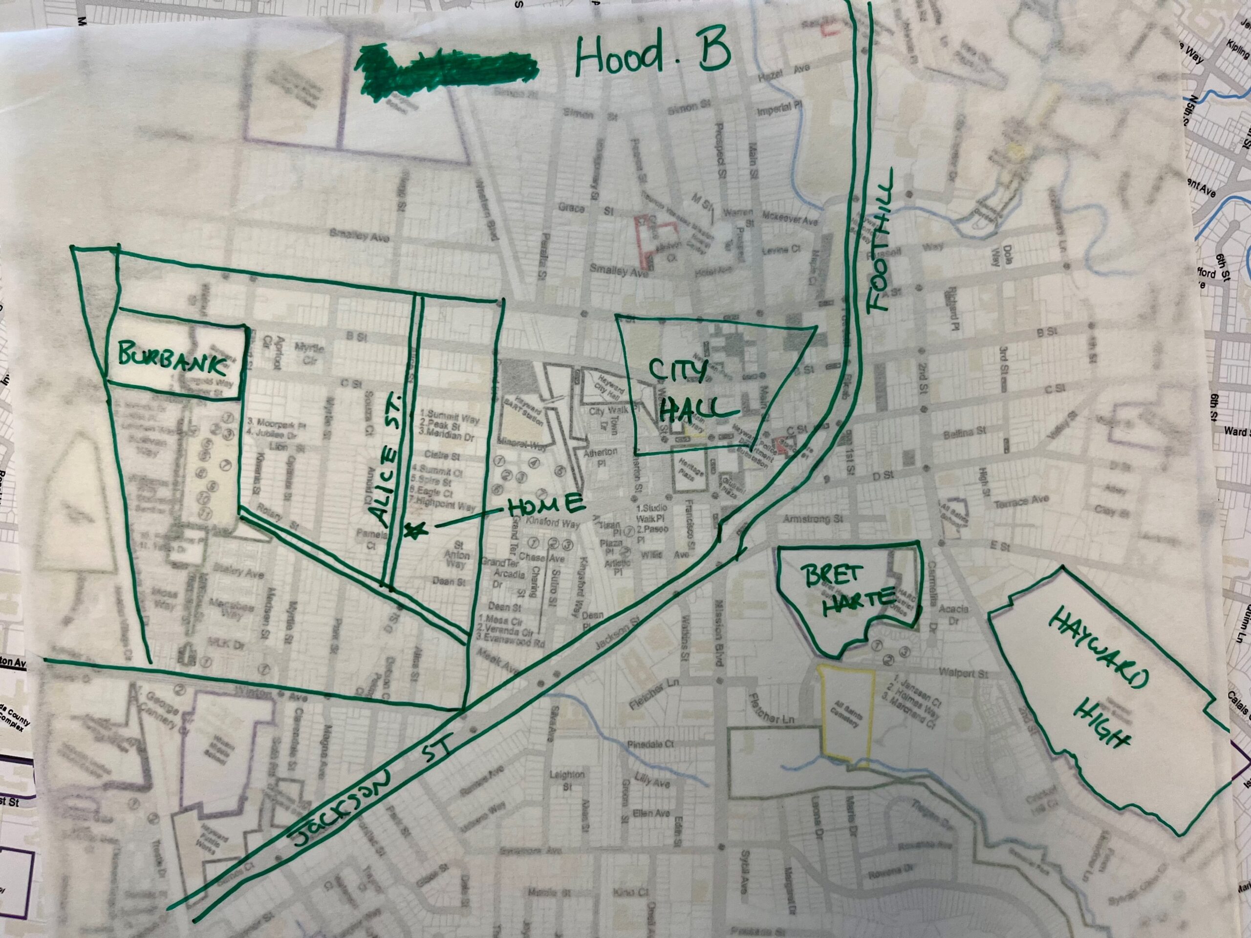
Regarding Hayward’s shift to district elections, I urge that the Jackson Triangle NOT be lumped with South Hayward, as city officials have done in the past.
The Jackson Triangle is more closely aligned with downtown Hayward than with South Hayward. For example, the Main Library is closer to Jackson Triangle residents than the Weekes branch library. Jackson Triangle residents use Hayward BART station, which is closer to Jackson Triangle than South Hayward BART. Jackson Triangle students attend Hayward High School, not Tennyson or Mt. Eden high schools. Etc., etc.
I rarely if ever frequent businesses in South Hayward
Richard Fierro on May 14, 2024 at 11:14 a.m.
Good morning, I am writing in opposition to switching to district elections. I recognize the city is being forced to do this because of a rogue lawsuit.
In my 35+ years as a citizen of Hayward I have never felt that any decisions the Council made prioritized one area of the city over the other.
When I look at our current Council I see what is probably the most diverse Council in the bay area. Switching to districts does not guarantee anyone will be elected, and if it does that is the antithesis of what is supposed to happen.
If we have to switch my preference would be for as many at large seats as possible.
I also would be willing to vote for a one time assessment or tax to raise money to fight this extortion
Chuck Purvis on May 13, 2024 at 2:52 p.m.
Hello Hayward!
I’ve produced some tables and maps that might be of interest in the ongoing process to develop city council districts for Hayward.
I’m looking forward to attending the meeting on May 14th.
Question #1: Has the City Council debated the option of creating five council districts and one “at-large” council member, similar to what’s in the City of Oakland?
Questions #2: Has the City Council debated the issue of acceptable error in the population differences between future council districts? I’m assuming the City will use the Census 2020 total of 162,954 persons, divided by 6 districts, equaling 27,159 persons for the “ideal” council district.
Attached documents:
1. The artist Jeanne Bertolina (2019) created a graphic showing the different neighborhoods of Hayward. I’ve got a print of this great graphic! It may serve as a good-hearted theme/image to this project.
2. I’ve created a map showing 18 neighborhoods of Hayward, based on the City’s official neighborhood districts, as adjusted to match the 2020 Census block boundaries. I then produced summary tabulations of the neighborhood population by race/ethnicity (see the following item.) Data matches the Census 2020 totals for the City of Hayward.
3. The PDF file “hayward_demographic_background_1.pdf” includes data from the US decennial census, the Census Bureau’s American Community Survey, and voter registration statistics from the California Secretary of State. There are a lot of stories to be told with these tables, but I just ran out of time.
Feel free to share this information. If the City would like the background Excel and GIS files, I would be happy to provide.
Graphic
Map showing 18 neighborhoods of Hayward
Hayward demographic background
Sherman Lewis on May 10, 2024 at 9:31 p.m.
There is no clear evidence one way or the other.
Districts greatly reduce the cost of campaigning and increase articulation/demands of the needs of each district, but also diminish responsiveness to the needs of the city as a whole, and encourages log-rolling of Council members looking to cut a deal for their district by supporting some deal for other districts for four votes at the cost of those left out.
This seems unlikely in Hayward given our strong propensity to be nice to each other, support vague priorities, and let staff do the specifics. We cooperate for consensus much more than we scheme to cut deals, which quickly gets just too complicated. The collegial reality is just the opposite of how most people think about politics.
City-wide has the advantage of candidates running for the city as a whole, but with more networking and campaign funds required. In a low participation city like Hayward, the networks of city-interested people are fairly small, and it is still possible to go door to door for frequent voters.
One way to balance is to have city-wide districts for one council member and mayor and 5 district reps. A district rep is likely to want to step up to city-wide as a basis for running for mayor in Hayward’s line-up-and wait system.
Debbie Frederick on May 10, 2024 at 8:11 a.m.
Please be aware of income & other differences in the neighborhoods BELOW, (ie downhill, or west of campus), CSUEB –Hayward vs those “above”, (ie east of campus). My home is below campus, & my ZIP code (94542) does not represent my community!
David Robinson on May 6, 2024 at 12:15 a.m.
I offer belated comments regarding item 8, LB 24-011, resolution of intention to adopt city council districts, adopted at the April 16, 2024 council meeting.
The council has acted appropriately by beginning a process to diligently consider district elections as a California Voting Rights
Act (CVRA) remedy, with community input. Because Hayward is not a highly segregated city, I expect that this remedy will prove unsatisfactory to both the City and the plaintiffs. The plaintiffs’ attorney, Mr. Rafferty, claimed on March 10 that “it is possible to
create at least one district that is majority Asian”, but he has not substantiated this by releasing a proposed map to the public. Mr. Rafferty claimed on March 21 that Hayward has forfeited its “safe harbor” option to adopt districts, in which case there is no reason to favor this remedy, or rush the process.
In 2023, the California Supreme Court clarified that several options other than districts are available to address under-representation of protected groups (Pico Neighborhood Association v. City of Santa Monica, case S263972). The court established a more specific test for vote dilution, so the current bar for plaintiffs to prove CVRA violations is not low, as the city’s attorney, Mr. Vigilia, claimed in his presentation. I urge the city and plaintiffs to work together to carefully consider all available remedies.
As a CVRA remedy, districts have drawbacks:
- The remedy can only work when a city has strong geographic segregation.
- It offers no benefits to protected group members outside of their designated districts, and could hurt them if they are isolated by district lines. This could invalidate a district remedy, according to Pico.
- If a district has two strong candidates that would both be chosen in an at-large election, no more than one can win.
- Voters have fewer choices than in at-large elections.
- Voters in a district who dislike the winner have no path to satisfactory representation
- Drawing district lines splits groups of voters who wish to act together, sometimes leading to bitter disputes, as occurred recently in San Francisco’s supervisorial redistricting.
- Districts do not always improve representation of protected groups.
Proportional ranked-choice voting (PRCV), first used in Alameda County
by Albany in 2022 to resolve a CVRA claim, is an option cited by the
California Supreme Court that avoids these flaws:
- PRCV retains the at-large representation that Hayward currently enjoys.
- In practice, nearly every voter helps elect a winner.
- Candidates appealing to protected groups can live anywhere
in the city. - All voters enjoy a diverse list of candidates.
- Multiple candidates appealing to protected groups can be elected if popular enough. Mr. Rafferty states that 34% of Hayward
voters are Asian-American. If they were to all vote for Asian-American candidates in an at-large PRCV election without
staggered terms, they could elect not just one but two council members representing the whole city. - Protected groups (and women) increased their representation in many cases where this method was adopted in the United States and elsewhere.
- Through a court settlement, PRCV could be implemented in time for the 2024 election.
In light of the Pico decision, the San Francisco school and city college boards are working with Mr. Rafferty to consider PRCV. Burbank and Santa Monica are considering cumulative voting, a semi-proportional method that is a common federal Voting Rights Act remedy. I encourage careful consideration of non-district alternatives in cooperation with the plaintiffs. This will ensure that Hayward invests in an election method with the strongest likelihood of improving representation of protected groups without imposing undue constraints on voters and candidates. Finally, I ask that the city acknowledge that non-district CVRA remedies exist on the maphayward.org website.
George Herbert on May 2, 2024 at 4:47 p.m.
Could you add to the districting website the applicable state and county and city laws and regulations that apply to creating districts?
Also, how many districts or council members are required or desired?
Beth Marshburn on May 2, 2024 at 4:07 p.m.
So much angst has already gone into other mapping and line-drawing efforts. I’m thinking at least of the projects where community members voted on spending budgets on projects in their neighborhoods – what were those neighborhoods? Nextdoor has way too many unrecognizable “neighborhoods” but they could be put up as straw lines. I’m just wondering whether you could seed the Draft Maps with a couple of things that are clearly labeled as “****NOT submissions, but for ideas only****” – something like that? Since there are So many maps up there now.
Beth Marshburn on May 2, 2024 at 3:47 p.m.
I haven’t read all the new material yet (if there is much?) but all I gather so far is that we will have district-based representation, which is good. But in several places I’ve lived that successfully used this, they’ve also had (at least) a single at-large member. I hope that’s being considered.
All I see so far is about drawing maps, which is important. But it’s only one prerequisite for district-based representation, and I hope we don’t spend all our time map-drawing without attention to the process of actually moving to a new election system.
I’m saying I’d like to see this happen; let’s don’t duck around for the next several years and get nowhere, please.